desert

How To See Valley Of Fire State Park in One Day

We talk a lot about National Parks, but what about State Parks? Valley of Fire State Park is Nevada’s first state park, and even though it’s a desert full of red rocks, petroglyphs, and gorgeous hikes now, it was once completely underwater and home to an entirely different array of wildlife to the lizards, snakes, and desert tortoises that call it home now. Valley of Fire State Park is a fairly small park next to Lake Mead, and while you can definitely spend more than one day here, it’s also more than possible to see it in less than 24 hours. This is the ultimate itinerary for seeing Valley of Fire State Park in one day. Let’s start at the West Entrance to the park…

(Do this itinerary backwards if you’re entering from the East Entrance)

The Basics

Valley of Fire State Park costs $10 USD per car per day. As budget travelers, this was the inspiration for our one day trip—we didn’t want to pay a second time! Valley of Fire is also extremely dog friendly and our Border Collie, Lassen, was able to join us on every trail we hiked that day. None of the trails are extremely hard, even the longer Fire Wave Trail. I hiked everything in trekking sandals just fine!

ValleyOfFire2.JPG

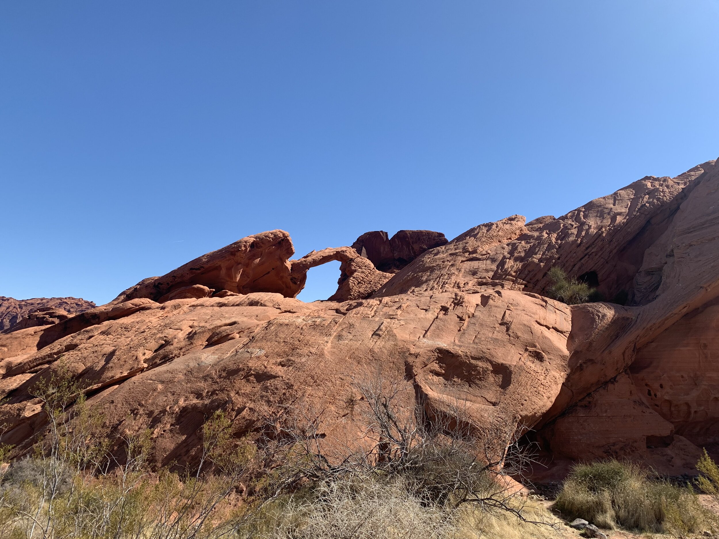
Stop 1: Atlatl Rock and Arch Rock

The first major stop you’ll want to make during your day trip to Valley of Fire is Atlatl Rock and Arch Rock. They’re really close to each other, and you’ll find them near Atlatl Campground. Atlatl Rock is one of the main petroglyph sites in the park, some of which are over 4,000 years old. Arch Rock is your classic arch, and the good news is, it’s right next to the road, so you won’t have to hike yet if you’re still waking up!

Stop 2: Visitor Center

This is the only place dogs aren’t allowed, but it’s a good stop for you to get the lay of the land, ask some rangers your questions about the park, see the museum, and hit up the gift shop!

IMG_7914.jpeg

Stop 3: White Domes Road

While this isn’t technically a stop, this is the next place you’ll go during your journey. This road is about 6 miles one way, and isn’t recommended for oversized vehicles (25 feet +). This is the view you see when you look up pictures of Valley of Fire. Our next two stops are on the White Domes Road, so keep your eye on the map so you don’t miss them! There are plenty of other things you can stop and do, but these next two hikes are a must-do as long as the weather is nice!

ValleyOfFire1.JPG

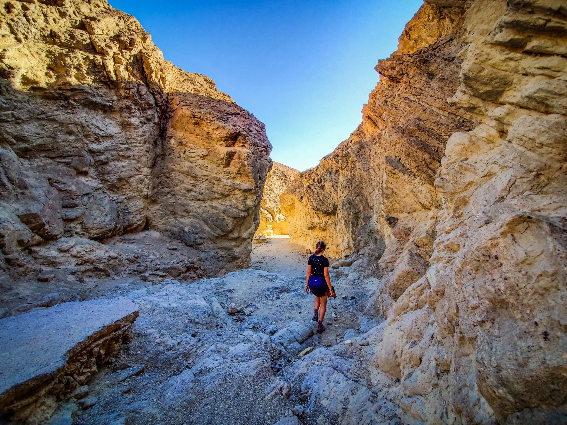
Stop 4: Fire Wave Trail

This 1.5 mile hike is rated easy-moderate, depending on your hiking style. I personally did this hike in trekking sandals and found it easy. This trail starts off sandy and then turns to a rock trail that you must follow cairn-style posts to hike. You’ll end at a beautiful rock formation (pictured below) that’s reminiscent of Arizona’s “The Wave,” which you need permits to hike.

IMG_7984.jpg

Stop 5: White Domes Trail

This is one of my favorite trails in the southwest. This short hike is only about a mile long, and is rated easy-moderate. It is a bit hard to follow unless you know to look for cairns, but it features a slot canyon, colorful rocks, and a historic movie site.

Stop 6: Elephant Rock

Our last stop of the day was Elephant Rock, a trail that’s located at the East Entrance. Elephant Rock is exactly what it sounds like—a rock shaped like an elephant! It’s only about a half a mile hike, and it’s rated easy. Make sure you keep an eye out though! You might miss it!

IMG_7921.jpeg

Valley of Fire is a state park that needs to be on everyone’s list. With plenty of easy and dog friendly trails to hike, you can’t go wrong with spending a day at this underrated southwestern park.

Sedona, AZ Bucket List

Sedona, AZ is already a bucket list destination for hikers, photographers, spiritualists, and vanlifers, but what do you do once you get to Sedona? From the crowded trailheads, to the must-see Uptown Sedona, this is everything you need to do and see in Sedona, AZ.

What to know before you go…

The best time of year to visit Sedona, according to the weather, is between October and April, but the best time of year to visit according to the crowds is in the summer. Sedona is located in Northern Arizona, so it gets really hot in the summer, making it almost impossible to hike. In the winter, though, the crowds make it so that you need to choose a hike the night before, and get there first thing in the morning in order to find a parking spot that allows you to actually hike.

Most hikes in Sedona that aren’t affiliated with a state park are dog friendly, so feel free to bring your furry friend along!

On the Soldier’s Pass Trail

On the Soldier’s Pass Trail

Visiting Sedona Vortexes

Sedona is a highly spiritual location full of energy Vortexes. These are natural spaces that are known to be super energetically charged, so much so that spiritual people can feel an energy shift while they are near them. You can recognize them by the swirly “vortex trees,” and they’re often found at the top of hikes like Cathedral Rock and Boynton Canyon.

At the Boynton Canyon Mesa

At the Boynton Canyon Mesa

Hikes You Should Do

Sedona is known for hiking. This is the main thing we do whenever we visit Sedona, and there are so many trails, I definitely haven’t hiked even close to all of them. These are my favorites for first time visitors, though, so that you get the best experience.

Devils Bridge: 4 miles RT, easy-moderate. Devils Bridge takes you to the famous bridge arch formation, where you can get your perfect picture. The trail starts on a 4x4 dirt road, and eventually climbs to the viewpoint. Be careful on the bridge though—it’s narrow!

Devils Bridge Trail

Devils Bridge Trail

Cathedral Rock: 1.2 miles RT, moderate-difficult. Cathedral Rock is a straight ascent of about 700 feet up to a beautiful viewpoint and spiritual vortex. This hike involves some heavy rock scrambling, and I highly recommend going in real hiking boots.

Solider’s Pass Trail and Seven Sacred Pools: as long as you want it to be, easy-moderate. The Seven Sacred Pools are an easy .25 miles from the trailhead, but if you want to go to Soldier’s Pass or the nearby caves, you’ll be doing about a 4 mile hike. We liked returning by walking the 4x4 road to avoid crowds going to the Seven Sacred Pools from Jordan Pond.

The Birthing Cave: 2 miles RT, moderate. This cave trail is easy until it reaches a steep ascent during the last .25 miles to the top. Traditionally, Hopi women came here to give birth, which is part of how it got its name (the other reason being its yonic shape). This is a very busy trail, so be prepared for crowds, and if you want a picture perfect scene for the ‘gram, get there early!

Cathedral Rock Trail

Cathedral Rock Trail

Healthy Hippie Bites

Sedona is a true hippie town full of amazing plant based food. These are my favorite spots for any meal, any time of day.

ChocolaTree: If you’re looking for amazing lunch or dinner food, ChocolaTree has you covered for vegetarian food. With options for any budget and diet, including raw vegan, you’ll love this organic eatery. My favorite thing to order at ChocolaTree is the Mushroom Fantasy.

Local Juicery: If you’re looking for a quick bite for lunch, Local Juicery is an amazing choice. From smoothies and juices, to easy on-the-go meals, this is the place to stop for any food you’re craving. My favorite thing to order here is the Avocado Toast.

Berry Devine: For anyone trying to cool off after a hike, Berry Devine has got you covered. This acai bowl place carries organic acai soft serve perfect for quenching any thirst. My favorite thing to order here is the Vortex Bowl with agave instead of honey and vegan granola.

At a Vortex just after sunrise

At a Vortex just after sunrise

Visit Uptown

Shopping, believe it or not, is another thing you have to do in Sedona. But not just any shopping: crystal shopping. Sedona’s Uptown is their version of downtown, with shops after shops, and restaurants you won’t find anywhere else. Aside from the clothes and art galleries, you’ll find endless metaphysical shops in Uptown, and these are the perfect spots to buy crystals and other spiritual goodies during your trip. My favorite metaphysical shop in Uptown is called the Center For New Age, a shop where the spiritual energy is high, and you’ll find the most genuine crystals in town. They also have affordable incense, a spiritual bookshop, and a vortex at the back of the store.

IMG_7868.jpeg

Sedona, AZ is one of my favorite places in the US, and as a spiritualist, it’s a must see for anyone who connects to the energy of the universe. Even if you’re skeptical, no one can doubt that the hikes here are incredible, and there’s no chance that there is a more beautiful desert town in the Southwest.

Live in a van? Check out last year’s Vanlife Guide to Sedona at the link below!

National Parks and National Emergencies

Visiting Death Valley During COVID-19

It was only a matter of time before I had to start addressing COVID-19 on here. As a travel blog that specializes in adventure travel, the world has felt a little weird lately. People can’t go outside, trails are closing, and only a few National Parks remain open. While certain small and high traffic parks have closed, such as Yosemite, Rocky Mountain, and White Sands, some do remain open with modifications.

I am currently living on the road full time. What this means is that I carry my house with me, like a snail, and have been isolated on public land for the past almost-week. While California does have a “shelter in place” order, it was stated that driving no more than an hour to spend time outside is okay, so since the public land I’m calling home was one hour from Death Valley National Park, I wanted to take the opportunity to go in, see the park for the first time, and address how the world has had to make modifications due to this global pandemic.

Golden Canyon Trail

Golden Canyon Trail

Currently, all National Parks are free to enter. Please keep in mind that National Parks are different from National Forests, which are run by the USDA, rather than the NPS. Largely, National Parks are not staffed right now. Visitor Centers are closed nationwide and bathrooms, campgrounds, and other facilities like parking lots that need to be maintained are locked. While Death Valley remained open, it felt like a very different, almost eerie experience to visit during this time. With only one ranger sighting throughout the entire park, multiple road closures, and 40MPH wind gusts, visiting a National Park during a National Emergency was an adventure to remember.

Please note: it is inadvisable to travel to National Parks during the COVID outbreak. I live full time on the road, mostly on BLM land, where I am able to isolate. I did not travel to go on a vacation in the National Park. This is my lifestyle, and I am treating it no differently than if I was in a house driving an hour to hike a local trail.

Zabriskie Point

Zabriskie Point

About Death Valley:

Death Valley is the largest National Park in the lower 48, and spans across both California and Nevada. It is most commonly accessed through the west, and we entered through Lone Pine, CA, which is where we are camped. Death Valley is a bit of a mismatched park. It has a little bit of everything, from mountains to desert, and each of its main attractions don’t really feel like they should fit together. From sand dunes to the lowest elevation in the United States at the Badwater Basin Salt Flats, Death Valley is a unique park that should be added to your list for future trips.

Mesquite Flat Sand Dunes

Mesquite Flat Sand Dunes

Restrictions in the National Park:

While Death Valley remains open at the time of the publication of this piece, there were restrictions within the park. Most visitor centers nationwide are closed right now, as are all public restrooms, lodging/camping, and pay stations. In Death Valley specifically, we were surprised to see that Panamint Springs was open, meaning we could get gas on our way into and out of the park. All parking lots were barricaded, so street parking was our only option for the sites that were open. There were also unexpected road closures, which caused for some disappointment as we tried to access Artists Palette, Dante’s View, Natural Arch, and Devils Golfcourse.

Badwater Basin Salt Flats

Badwater Basin Salt Flats

What was accessible?

Despite the restrictions, quite a lot was still accessible, and due to the lack of visitors, it was completely possible to still be isolated while in the park. We did not come into contact with any other people, and as avid hikers and outdoorsy humans, we always leave no trace, and that includes the spread of COVID (hands were washed often and we were careful to only touch the natural features of the park).

We were able to access the Mesquite Flat Sand Dunes, Badwater Basin Salt Flats, Golden Canyon trail, Ubehebe Crater, and Zabriskie Point, so we felt like we got a decent overview of the park, even though we had less than 12 hours there altogether.

Mesquite Flat Sand Dunes

Mesquite Flat Sand Dunes

The thing is, this trip to a National Park was incredibly different from any other National Park trip I’ve taken in the past. While this was my 35th park, it didn’t feel quite the same without a trip to the visitor center, open roads, and maps to collect. But the thing is, although we visited out of convenience and a need to get outside during this self-isolation, the park isn’t going anywhere. I can always go back and experience it in full. It’s time to let mother Earth heal first, and then the adventure can continue.

-HWS

Where My Travel Bug Was Born

An Ode to Vasquez Rocks

All travelers have to start somewhere. For me, it was in a county park that now feels so small, but holds so many memories. As soon as I was old enough, my parents started taking me to Vasquez Rocks County Park in Agua Dulce, California on a regular basis. My dad had come here as a kid as well, and if I have kids, and live in California, you can guarantee they’ll be climbing the same rocks.

My younger years at Vasquez were filled with nearly empty picnic spots, eating peanut butter sandwiches and tortilla chips on the rocks, and hunting for petroglyphs. Vasquez is a special place, and as much as it changes nearly every time I visit, the rocks are always the same, and the ravens still crow, and the tree we used to park next to still stands.

The Main Vasquez

The Main Vasquez

Vasquez Rocks is quite famous. You’ve likely seen its towering “main Vasquez” in commercials, or perhaps an episode of Star Trek, and the Pacific Crest Trail passes right through the park. But these aren’t the reasons it has a special place in my heart.

Vasquez Rocks for me represents the seeds of exploration. I associate its sandstone rock forms with my Peter Pan days of playing pretend and going on adventures that seemed big at the time. It was where I took my first hikes, scrambled my first rocks, and got my first few scraped knees. And now that I’m older, and the adventures have gotten bigger, I find myself reminiscing on those days more than ever, and have found myself returning to the park more often, making new memories.

Me as a young child, learning to rock scramble

Me as a young child, learning to rock scramble

I’ve since discovered new trails at Vasquez Rocks, and new parts of the park that I hadn’t paid much attention to as a kid. I found out that the park is dog friendly, and took my family’s dog, Josey there when we visited for my 21st birthday forever ago. Now, I’ve spent time studying the rocks with Jared (@jaredinthevan) as bouldering and climbing started to peak my interest.

The sandstone rocks of Vasquez

The sandstone rocks of Vasquez

We all have our safe spaces, and for me right now, those spaces are outside. It’s never a bad thing to revisit some childhood memories, either by physically going to the place, or through photographs (or both). Vasquez Rocks for me is a place that will always be there, no matter how much its changed over the years, and in times like these, it’s important to remember what made you the person you are today, to stay grounded, to not lose hope.

-HWS

I Took a Secret Tour of Joshua Tree

I’ve been to Joshua Tree 5 times in my life, 4 of them in the past year, and 2 of them in the van. This time around I definitely felt as local as you can get in a National Park, but at the same time, I knew there was so much more to discover.

When The Secret Tours reached out to me, I was immediately intrigued—discovering more about a place I’ve been before? Having an excuse to go back? Yes please! So during this trip to Joshua Tree National Park, I participated in a couple of their tours so that I could see a little more of this amazing place I’ve grown to love.

The Secret Tours is a self-guided tour company in the Joshua Tree area, and they have a few different tours to participate in. On this trip, I did the Walking Tour and the National Park Tour, and both were super fun! They combine the idea of a scavenger hunt with exploration and fun facts about the area to make exploring interesting for all types of travelers. My team was made up of me and Transit Connect vanlifer Jared (@Jaredinthevan on insta!), and while it was my fifth time to the park, it was Jared’s first, so taking the National Park tour made for a really cool experience: me discovering new places I hadn’t seen before, and Jared seeing the whole park for the first time.

Don’t climb skull rock unless you know what you’re doing! The view from the bottom is pretty cool too!

Don’t climb skull rock unless you know what you’re doing! The view from the bottom is pretty cool too!

All of the tours start at the Joshua Tree Visitor Center in Joshua Tree, California. For the National Park tour, you’ll then go into the park and start discovering new destinations along the road, and answering questions about your observations as you go.

This tour will take you through the entire park, and as far south as the Cholla Cactus Gardens, your clues adding up to one big answer at the end of the tour!

Sunset from Quail Springs

Sunset from Quail Springs

Some of our favorite stops:

Cholla Cactus Gardens- This is an all time favorite of mine, so I was super excited to see it on this tour! This is one of those must-see stops in Joshua Tree, but make sure you experience it right by seeing it with The Secret Tours!

Chollas chillin’ in the Cactus Gardens

Chollas chillin’ in the Cactus Gardens

The Adventurous Yucca- This is the oldest Joshua Tree, but I won’t tell you where in the park to find it—I’ll leave The Secret Tours to that one! This is a fun spot to hit because at the very beginning of the tour you have to figure out how old it is!

The oldest Joshua Tree… can you guess how old it is? Or, you can go on the tour to find out!

The oldest Joshua Tree… can you guess how old it is? Or, you can go on the tour to find out!

Keys View- Again, I’m not gonna tell you where to find this one, but you can’t really miss the signs pointing you in the right direction! This is a super cool spot that I didn’t even know was here, despite the fact that I’d been to the park 5 times!

Quail Springs- While we experienced this spot at the beginning of the tour, we actually ended up coming back here at the end of the day for the sunset and some rock scrambling, despite the long drive through the park! I loved that this tour showed me some spots worth revisiting, other than my normal go-to’s.

Key’s View! Joshua Tree’s very own Grand Canyon!

Key’s View! Joshua Tree’s very own Grand Canyon!

For your next trip to Joshua Tree, The Secret Tours should be on your to-do list! They’re a great way to get the lay of the land and experience the entire area in and surrounding the park to the fullest! While the main tour I did while I was in the area was the National Park tour, they also have their walking tour and a longer driving tour around the area that surrounds the park to take you to some cool desert art, alien-related spots, and more! So head on out to the California desert—you might just discover some secrets…

Your Guide to the Southern California Desert

I’ve now pretty much finished Southern California. It’s where I grew up and went to school, so I’ve got a pretty good gauge of its geography. And on top of that, there’s basically no major destination in the southern portion of the state that I haven’t traveled to. There are a few main landscapes in Southern California: from mountains to beaches to deserts. They say it’s one of the only places you can go surfing in the morning and skiing in the afternoon. But a large portion of Southern California is taken up by desert, and a few of these deserts are very worth your visit, while some are just transitional spaces between states (I’m looking at you, Mojave). This is a short guide to the deserts worth seeing, why you should visit, and what there is to do there.

Joshua Tree National Park

Joshua Tree National Park

Anza Borrego Desert State Park

Anza Borrego Desert State Park is actually known for its correlation with the famous California Wildflower Superbloom that happens in spring seasons that follow winters where we get a lot of rain. While a superbloom is unlikely in 2020, this desert is still worth your visit. It’s the largest state park in the contiguous United States, and touches three counties: San Diego, Imperial, and Riverside. There are also a lot of free campgrounds in Anza Borrego, and you do not need to pay the park entrance fee ($10) to stay in them overnight. You’ve likely heard about Anza Borrego from the Sky Art Sculptures: giant metal sculptures built to work with the landscape or look like they’re a part of it. These sculptures invoke feelings of whimsy, and bring you back to the most childlike parts of your imagination (pictured below).

The Serpent, Anza Borrego Desert State Park

The Serpent, Anza Borrego Desert State Park

Joshua Tree National Park

I’ve talked about Joshua Tree a lot on this blog, and even have a full guide to the park available HERE, but it needs to be on this list because it’s one of the main desert attractions in Southern California. Home to over 2 million Joshua Trees, a member of the agave family, Joshua Tree National Park is known for rock climbing, photography, and general exploring. It’s a huge park with plenty to do for every kind of traveler. Going with kids? Check out Jumbo Rocks Campground, Skull Rock, and Arch Rock. Adventure Seeker? Go find the Hall in the Hall or Horrors, summit Ryan Mountain, or go scrambling on one of the many rock formations. Just trying to take some good pictures for the ‘gram? Head over to the Cholla Cactus Gardens or stop in any roadside pullout for a good photoshoot with some J Trees! There’s also tons to do in the area, from stopping and grabbing a bomb vegan sandwich and getting some work done at Frontier Café to taking a self-guided tour with The Secret Tours.

Joshua Tree National Park: Sunrise from Belle Campground

Joshua Tree National Park: Sunrise from Belle Campground

Slab City, The Salton Sea, and Salvation Mountain

These spots are important for any SoCal desert tourist, but I honestly can’t see myself going back anytime soon. Salvation Mountain is a famous piece of desert installation art in the middle of Slab City, a strange desert town. It’s definitely worth seeing, and while you’re there, make sure you visit East Jesus—another space for desert art. As for where to stay during your time here, I highly recommend the Salton Sea. It’s close by, but not so close that you’ll feel the general weirdness of the Slabs. The Salton Sea is a huge body of water with a strange history, and the beach is made of fish bones. Just beware—the Salton Sea doesn’t smell its best!

Salvation Mountain, Slab City, CA

Salvation Mountain, Slab City, CA

The SoCal desert is an incredible landscape that shouldn’t be missed. So many people say they’re coming to California and stop their journey south at Los Angeles, when really, there’s so much to be seen. The desert lies inland, and will give you a much broader scope of what California is made of. The desert is a place of extremes, so you might want to make sure you stock up on water, but also bring your 0 degree sleeping bag with you (don’t have one? Check out my favorite bag HERE!). But above all, make sure you take plenty of pictures—the desert has a certain beautiful magic to it.

Exploring Tucson's Nature

Saguaro National Park and Mount Lemmon

Generally, I’m the type of traveler who travels for the natural landscapes. I go from National Park to National Forest to State Park and try to avoid cities, but there are a few cities that are so surrounded by nature that exploring their parks has become the main attraction. I didn’t quite realize how engrained in Tucson’s culture Saguaro National Park and Mount Lemmon were until a fellow vanner told me, “There isn’t much to do in Tucson except to visit the national park and drive Mount Lemmon.”

After four nights of weather so cold I had to break out the 0 degree sleeping bag, I finally made it back to the southern part of the state. I had already been planning on visiting the park, but as usual, I didn’t have too much of a plan for my day. I ended up fitting both destinations into my one full day I had in Tucson. Here’s everything you need to know.

**Usually I’d stay a bit longer in a place, but cities are expensive and I have to sleep in parking lots, which can be noisy, so I decided I’d want to stay only for a little bit before heading back to the coast.**

Saguaro National Park: how many different types of cactus do you see here?

Saguaro National Park: how many different types of cactus do you see here?

Saguaro National Park

There are two sides to Saguaro National Park: the West and the East. Since the East was closer to where I was staying in Tucson and was much closer to Mount Lemmon, I decided that that would be the side I visited during my time there. The West side is a bit out of the way, yet boasts bigger and older saguaro cacti.

East Saguaro has a small park or monument feel (basically, it’s not Yosemite, it feels more like Craters of the Moon). There isn’t too much to do but what there is to see is gorgeous. Since I only had half the day in the park before driving Mount Lemmon, I was recommended to do the Loop Road and walk the Desert Ecology Trail. Between this and getting out of the van to take a few pictures and video with and of the cacti, I felt like I saw the basics of what the park was about.

It’s also worth stopping in that Javelina Picnic Area for lunch, as all the tables are surrounded by desert plants, and it allows you to get up close and personal with the cacti.

Saguaro is a place of desert diversity, and is home to far more types of cactus than just the Saguaro. This National Park is home to 24 different types of cactus, and they’re all incredibly unique.

East Saguaro National Park

East Saguaro National Park

Mount Lemmon

If you like saguaros, you’re in luck: the bottom of Mount Lemmon is covered in them—even more than are in the East side of the National Park! Mount Lemmon is known for being a place where you’ll experience all of the different biospheres that you would if you were to drive from Mexico to Canada.

There are five biosphere’s total in this unique National Forest (Coronado National Forest) ranging from Sonoran Desert, to Ponderosa Pines, to Mixed Conifers at the summit. I was so happy to see pine trees again without it being absolutely freezing, so if you’re a mountain person stuck in the desert, this is definitely the drive for you.

Mount Lemmon is also ideal for road cyclists, but be warned: it’s a 27 mile journey to the top!

One of the lower biomes of Mount Lemmon

One of the lower biomes of Mount Lemmon

The entire drive from the bottom to the top of Mount Lemmon takes about an hour and ends at a ski resort. I was unable to go the last two miles to the top because the road had been closed due to snow. Throughout the drive, you’ll pass plenty of roadside pullouts, picnic areas, campgrounds (if you’re into that—I don’t believe any of them are free), and one visitor center that has a museum about the area inside. If you go in the winter, try to go on a warmer day, or a little later in the winter, as there was still tons of snow on the sides of the road.

As close the the summit as they would let me drive, Mount Lemmon, AZ

As close the the summit as they would let me drive, Mount Lemmon, AZ

Tucson was completely full of surprises for me. I of course expected to like the National Park, but I didn’t expect it to be so easily accessible from the city. Mount Lemmon, however, was a total surprise for me—I knew it would be beautiful, but no one expects pine trees in southern Arizona. Basically, don’t take anything at face value—every destination has a hidden gem waiting just around the corner, or maybe, at the top of a summit.

A Vanlife Guide to Sedona, AZ

If you’re a person who lives on wheels, or even just a person who hates winter, it’s no secret that Arizona is the place to be in January. Nearly every person living that vanlife on the west coast (and some from the east!) comes to Arizona at the end of January every year. After the annual gatherings in Quartzite, me and my new Van Fam (follow them at emma.goes and theotherground) headed out to Sedona, a place I’d been dreaming of visiting for about two years now.

Sedona is one of the most powerful spiritual centers in the country, and is home to tons of red rocks and beautiful hikes. Prior to coming out here, I had no idea how easy it would be to be an overlander in Sedona, but the truth is, Sedona is one of the most vanlife friendly cities I’ve ever visited.

Me and Emma at Cathedral Rock. Photographer: Brien @theotherground

Me and Emma at Cathedral Rock. Photographer: Brien @theotherground

Where is Sedona?

Sedona is located in north-eastern Arizona, making it one of the colder areas of Arizona. It is about 7 hours from the California coast, 5 hours from Joshua Tree, and 3.5 hours from Quartzite, AZ.

Where should I park?

As I said, Sedona is incredibly van friendly, but that means it’s incredibly camp friendly too. This isn’t the type of city where vanlifers are lining the streets, it’s a city surrounded by National Forest land. The best spots to park are along Forest Road 525. You’ll be sure to meet plenty of other van dwellers, and if you drive far enough, you’ll reach the Palatki Native American Ruins. You obviously can’t park at the ruins, but there are spots nearby where you’ll have vast views of the red rocks.

At camp, somewhere on FR525. Photographer: Emma @emma.goes

At camp, somewhere on FR525. Photographer: Emma @emma.goes

What are the best restaurants?

We frequented two amazing vegan/vegetarian restaurants while we were in Sedona: ChocolaTree and Local Juicery. A few of our friends actually work at Local Juicery, so definitely go say hi and support your fellow vanlifers (plus, their avocado toast is the best I’ve ever had). ChocolaTree is more of a spiritually minded spot. It has more of a sit-down restaurant feeling to it, so it’s worth going if you’re craving a hot dinner.

Where can I get water?

Living off the gird means certain things aren’t as easy as they could be in a house. One of those things is water. Luckily, ChocolaTree has a spigot with fresh spring water outside their restaurant that they allowed us to fill our 6 gallon tanks with.

Me at Devils Bridge—the most famous hike in Sedona! Photographer: Emma @emma.goes

Me at Devils Bridge—the most famous hike in Sedona! Photographer: Emma @emma.goes

Where can I go to get in a work day?

There’s always Starbucks, but if you’re looking to get in a work day and catch some views, head to Creekside Coffee. Here, you’ll have views of Snoopy Rock, and can snag some WiFi, even outside.

If you’re interested in learning more about making money on the road, check out Wired Creatives HERE!

Cathedral Rock from below

Cathedral Rock from below

What are the best hikes to do?

If you’ve been following me for a while, you know that hiking is a huge reason I go to certain places. Sedona is a huge hiking hub, so we made it a point to hit a few of the Coconino National Forest trails while we were out there.

Devils Bridge: Devils Bridge is easily the most popular hike to do in Sedona. It features a vast, natural bridge photo op and the entire hike is about 4 miles long. Expect crowded parking, but if you have 4WD, you can make it to the real trailhead and skip walking along the dirt road. If there’s no parking, no worries, you can park on the main road too, but it’ll add about a half mile of walking. Prepare for crowds at the top too. We got lucky with a gloomy day, and only had to wait behind about 6 people each, but normally, it’s a crowd of about 150 people at the top.

Boynton Canyon Vortex: This was one of the most powerful vortexes I experienced in Sedona. It’s not a long hike, but it features red rocks and two spires that are said to represent the divine masculine and divine feminine. If you’re a spiritually minded person, you’ll love this spot, and if you get there early enough in the day, you might just catch the flute player who goes up there daily to hand out heart shaped rocks to people.

Cathedral Rock: This was my absolute favorite spot we went during our time in Sedona. It’s a hike basically made of rock scrambles, which made is extremely fun, and had some amazing photo opportunities at the top. Keep an eye out for the vortex trees—trees that appear to have been swirled (this phenomenon happens due to the high amounts of spiritual energy in the area).

Me and Emma at Cathedral Rock. Photographer: Brien @theotherground

Me and Emma at Cathedral Rock. Photographer: Brien @theotherground

Sedona is an absolutely magical spot. Whether you’re a spiritual person or not, Sedona will change the way you see the desert. The hikes here are breathtaking, the camping is quiet and peaceful, and it’s a great place to feel like you have a sense of community on the road.

Your Guide to Carlsbad Caverns National Park

Carlsbad Caverns is one of my favorite southern national parks. Located in Southern New Mexico, just minutes from the Texan state line, Carlsbad Caverns is found in the Chihuahuan Desert, and was formed by sulfuric acid and limestone.

This is a small park, and it doesn’t have a campground. Because of that, there are only a couple things to do in the park, but that doesn’t make them any less spectacular.

Carlsbad Caverns is home to two of the most unique experiences I’ve had in national parks, and I’ve been to 33 of them. I went with my family during the section of my summer trip that they met up with me for, and we stayed in Carlsbad at a nearby hotel. This was my dad’s second time in the park, and the good news is, it hasn’t really changed much, so let’s head out, and explore what Carlsbad Caverns has to offer.

Inside the cave!

Inside the cave!

Camping

As I said before, Carlsbad Caverns doesn’t offer a campground inside the park. The good news is, one of its nearby parks does offer camping in an amazing little campground near the tallest peak in Texas—Guadelupe Mountains National Park. Camping here is $15 and you’ll have easy access to all of this park’s trails as well.

Tips for visiting

Carlsbad Caverns is one of the most accessible national parks for tourists. There are a lot of parks that require hiking in order to see the park’s beauty, but in Carlsbad Caverns, you’ll be able to experience everything this park has to offer on its paved walking trail.

While this park doesn’t require an admission fee, you do need to pay to enter the cave. Because of this, I highly recommend investing in an America the Beautiful Pass, Military, or Senior interagency pass for your admission, especially if you plan on camping in Guadelupe Mountains and visiting any other national parks in the country within the same year. Without a pass, everyone over age 16 is $15 for entry, but the pass will get a family of 4 in for free.

Sunset from the visitor center in Carlsbad Caverns National Park

Sunset from the visitor center in Carlsbad Caverns National Park

Seeing the cave

I’ve visited a few caves around the country, and while Carlsbad Caverns isn’t the largest (Mammoth Cave, KY is), it’s definitely the most spectacular (in my opinion). There are two ways to enter the cave. If you’re not a hiker, I’d highly suggest taking the elevator. It’s a 700 foot journey into the earth, and you’ll be able to take your time exploring the cave’s paved path by foot. If you want to hike in, that is also an option, but know that the cutoff for admission to hike is 5 pm MST in the summer.

When in the cave, please stay on the paved path, and don’t touch the cave!

Ranger-led tours

If you want a more immersive experience when it comes to viewing the cave, you can sign up for a ranger-led tour. You can reserve your spot on a tour through the Carlsbad Caverns official website. Tours will take you through different areas of the cave, depending on how involved of a tour you want to do, and tours cost between $7 and $20 without a senior access pass.

The bat flight program

Every night at sundown, people gather in the park’s amphitheater to watch the bats leave the cave. This event is actually the way that Carlsbad Caverns was discovered in the first place. Around exactly the same time every night, the bats leave the cave to feed for the night, and it’s a spectacular sight you don’t want to miss.

Tip: bring food into the park. The park restaurant closes at 6 in the summer, but the bats don’t leave the cave until 8, so you might get hungry while you wait.

The view of the New Mexico desert from the visitor center

The view of the New Mexico desert from the visitor center

Carlsbad Caverns is a fantastic small national park. There isn’t a ton to do, but what there is to do is absolutely mind-blowing. If you’ve never seen a cave, this is a great place to start, but be warned, this one will raise your expectations for all caves you’ll visit after.

Another place to add to your list: MAMMOTH CAVE NATIONAL PARK

Mammoth Cave has over 600 miles of explored cave in the middle of Kentucky. It is the largest cave yet to be discovered in the world, and is free to enter the park. The cave is $6 to enter, and there is camping available in the park.


To visit Carlsbad Caverns, Mammoth Cave, and more, check out my ebook, Around the States in 90 Days!

A Complete Guide to Visiting the Grand Canyon

The Grand Canyon is among my favorite places on Earth. It was the site of my first ever solo trip, and will forever hold a special place in my heart. Located in Northern Arizona, the Grand Canyon is one of the Earth’s natural wonders, but it’s far more than just a hole in the ground.

At the bottom of the canyon is the Colorado River, flowing between the two main rims of the canyon. The Grand Canyon is home to a huge amount of wildlife, from elk to marmots to California condors, and it is the second most visited national park in the country.

I visited the Grand Canyon solo for three days during my last ever spring break. This was not only the perfect place for a solo trip due to the fact that it feels incredibly touristy and safe, but it was an absolutely beautiful place to visit alone. Being solo for this trip allowed me to really take it in, and this is a place you really have to be present for.

Being alone also allowed me to see most of the South Rim while I was there, which is the most popular section of the park to visit. This is your guide for planning your own trip.

Note: this post may contain affiliate links

View from the South Rim in March

View from the South Rim in March

So… there’s more than one rim?

Yes! The two main sections of the park are the North Rim and the South Rim. The South Rim is open year-round, and is located, well, further south, which means it’s a little warmer. The North Rim closes in the winter months and off season because it’s located at a higher elevation, and generally reopens in May. This elevation difference is so great, I’ve heard stories of people waking up to snow in the summer!

Most of this article will be about the South Rim, as it’s far easier to access for tourists.

Canyon wall on the South Kaibab Trail

Canyon wall on the South Kaibab Trail

Getting to the park

The South Rim is incredibly easy to access. It has that classic “pay at the gate” type of entrance most large national parks have ($35 to enter, or America the Beautiful or other interagency pass). The closest town to the South Rim is Tusayan, and if you don’t want to drive, you can park your car in town and shuttle into the park (highly recommended during busy weeks, such as holidays and spring break).

I hear a lot of questions about visiting the Grand Canyon from Vegas, and I just want to put it in here that the South Rim is a 5 hour drive from Vegas. It is not super accessible. You can visit the West Rim, which is not part of the national park, and is home to the glass Grand Canyon skywalk. This is a cool thing to do, but it is not the national park, and will not give you that classic experience.

View as you approach Skeleton Point on the South Kaibab Trail

View as you approach Skeleton Point on the South Kaibab Trail

Staying in (or near) the park

I’m a traveler who prefers campgrounds, so when I visited, I stayed in Mather Campground because it was the only one of the two on the South Rim that was open in March (yes, March is still considered winter!). I reserved my site 3 months in advance (during that good ol’ government shutdown, remember that?), so I’d recommend booking a site as soon as you decide you want to camp in the park. Hopefully, you’ll be greeted by a herd of elk, like I was (which you can see in THIS VIDEO)—just make sure you give them their space! There is also a hotel in the park, and a second campground open during peak season (summer months) called Desert View.

There is also a campground in the North Rim if you choose to experience the northern side of the park. It is called North Rim Campground and is first come first served ONLY for 2020.

If you can’t book a spot in the park, no worries! Like I mentioned before, the town of Tusayan is an awesome place to stay because you can shuttle into the park from your hotel. The town of Williams is about a 45 minute drive from the park, which also has plenty of hotel and Airbnb options.

Marmot hanging out next to Skeleton Point

Marmot hanging out next to Skeleton Point

What is there to do?

I’ve heard tons of people say that they’ve gotten bored at the Grand Canyon, but the truth is, there is so much to see and do! If you’re not a hiker, there are plenty of sightseeing areas to explore.

You can walk part of the Rim Trail, which is a flat, 13 mile long stretch with views from the top of the South Rim. Most people only do a couple miles and stop at various viewpoints. A great place to start is behind the visitor center, at Mather Point (different from Mather Campground). Here, you’ll get some of the best views from the South Rim.

It’s also always useful to make a stop at the visitor center. This is where you can get all of your questions answered and explore the museum to learn more about the park. Here is also where you can find out information about various ranger programs.

Other great viewpoints work seeing are Yaki Point (known for being a great spot to view the sunset), and Yavapai Point (accessible from the Rim Trail).

It seems to just go on forever…

It seems to just go on forever…

I’m a hiker, where should I go?

The Grand Canyon is huge for hiking. While there are trails rated difficult on both rims, the most famous trails in the park are Bright Angel and South Kaibab (there is also the North Kaibab Trail on the North Rim). Both trails go to the bottom of the canyon, but you cannot go to the bottom without a backcountry permit.

The difference between the two is that Bright Angel is longer, but not as steep, which makes it the more popular of the two trails. South Kaibab is far steeper, but also far less crowded. I did a bit of Bright Angel on my first day in the park, but it was a bit too crowded for my liking. The next day I took the shuttle to South Kaibab (there is no parking lot—you have to shuttle), and it was far more enjoyable.

There are three stops before the river on the South Kaibab Trail: Ooh Ahh Point (great for families with kids), Cedar Ridge (perfect for moderate level hikers), and Skeleton Point (awesome for advanced day hikers). There is a similar set of rest stops along Bright Angel: Mile and a Half Rest House, Three Mile Rest House, and Indian Garden. Both big trails are out and back trails, and you will have to hike up the way you came, so bring water and plenty of food and plan accordingly.

Crazy rock formations out here

Crazy rock formations out here

Phantom Ranch and Havasupai

If you’re at all on Instagram, you’ve heard of Havasupai: the famous blue waterfall in the Grand Canyon. And if you’re into hiking, you might’ve heard about Phantom Ranch and Phantom Campground. Both spots require a backpacking permit to visit, and permits to Havasupai are growing more and more difficult to get (and cost $150 per night per person). Please do not attempt these hikes without proper training and a permit.

While we’re on the topic of backpacking, it is also possible to hike from the South Rim to the North Rim, but you also need a permit to accomplish this. If you do plan on backpacking, please make sure you have the right gear, and a cold weather sleeping bag made for backpacking.

View from Mather Point

View from Mather Point

Anything else?

Of course, there’s so much more to experience, but these are the most notable, and with this information under your belt, you’ll be more than prepared for a trip to GCNP. The most important thing is to respect wildlife. Especially when larger wildlife like elk are present, it’s necessary to keep the Leave No Trace principles in mind and stay 25 yards away!

But above all, have fun! If you’re camping, make sure you have the right gear and you’ll have the best time—camping in the Grand Canyon is one of my favorite camping experiences. Make sure you carry water, but also carry a camera: this park will not fail to blow you away.

Leave your questions about the park below! I’d love to hear from you!